On August 15, 1950, India was celebrating its Independence Day. The mood was upbeat throughout the country. Just as celebrations were winding down for the day, a great disaster struck. At around 7:30 pm, an earthquake of magnitude 8.6 — the strongest ever recorded on land — jolted the country’s Northeast and some neighbouring areas beyond the border.
According to some reports, the earth shook for about four to eight minutes. Mountains stumbled and buildings fell, causing widespread death and destruction. An English botanist and explorer named Frank Kingdon-Ward was camping at Rima (Zayu) on the day. He reported later: “I was seated writing my diary near the entrance to our tent. Suddenly, after the faintest tremor, there came an appalling noise, and the earth began to shake violently. … We were immediately thrown to the ground. The lantern too was knocked over and went out instantly.”
The earthquake was felt over an area of 3 million sq. km across India, Myanmar, and Bangladesh, Tibet, and South China. It wrecked homes, farms, and railway tracks, bridges, and other utilities. A field investigation report described how “rail tracks were torn up and twisted into snake-like patterns”, in a vivid demonstration of how the land and structures deform in response to shear waves. On the Indian side alone, more than 1,500 people lost their lives, and 50,000 to 1,00,000 cattle were killed. The quake was felt as far afield as Lhasa and Sichuan, and in Yunnan province in China. In the Medog area of Eastern Tibet, Yedong village slid into the Yarlung Zangbo river, and more than 4,000 casualties were reported from Tibet. Severe damage was wrought in the Sibsagar-Sadiya area of Assam as well.
More destruction was to follow in the days after the earthquake. Many hills had been sheared by the earthquake. Rocky debris falling into the valleys below blocked rivers — before giving way days later, producing flash floods downstream that killed hundreds of people living on the rivers’ banks. On September 9, two weeks after the earthquake, the then Prime Minister Jawaharlal Nehru said in a nationwide broadcast on All India Radio: “The Brahmaputra was blocked up for a while, and then broke through, they came down with a rush and a roar, a high wall of water sweeping down and flooding large areas and washing away villages and fields and gardens. … The remains of villages, animals, including cattle and elephants, and large quantities of timber floated down these raging waters…”.
Revisiting the earthquake
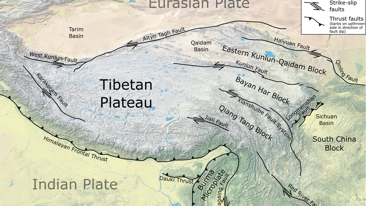
The source of the Great Assam Earthquake lay 40 km west of Rima (Zayu), the village near the India-Tibet border in the Mishmi hills where Kingdon-Ward was camped. The quake occurred along the boundary where the Indian and Eurasian Plates collided, near the eastern terminus of the Himalayas, at a depth of 15 km. The rupture extended from the Mishmi thrust of the Eastern Himalayas to the Himalayan Frontal Thrust of Arunachal Pradesh, completing a curvilinear motion around the mountainous bend (see image above).
As it happened, the shaking also occurred at a time when seismographic networks were expanding worldwide, providing great impetus to earthquake monitoring and the subsequent development of the theory of plate tectonics. It was also the time instrumental monitoring of earthquakes had started in India, with the India Meteorological Department (IMD) setting up its first seismological observatory at Alipore in Kolkata district in 1898.
Today, we understand the Great Assam Earthquake happened on a plate boundary formed by the collision of continental plates, like those along other parts of the Himalayan plate boundary. However, it is differentiated by the fact that its source was in the Eastern Himalaya, which is tectonically very complex. GPS data indicate that while Indian and Eurasian continental plates are converging at about 20 mm/year on average across the Himalayas, in the Eastern Himalayas it ranges from 10 mm to 38 mm/year.
This variation could very well be due to difficulties in capturing tectonic complexity and differences in data quality. While the main arcuate Himalaya plate boundary resulted from the collision of the Indian and Eurasian plates, the Sunda plate is also involved in the northeastern Himalaya, creating a complex structure.
Due to plate rotation, major structural elements also take sharp turns and the regional strike shifts from the general NE-SW direction to the NW-SE direction post-collision, forming what geologists call the Eastern Himalayan Syntaxis (EHS). This is where the Great Assam Earthquake likely occurred.
Unlike other Himalayan earthquakes, which have exhibited a thrusting mechanism — where one block of the fault thrusts over the other — the Assam earthquake displayed a component of strike-slip motion, with both blocks sliding past each other along the fault. This suggested it was connected with the EHS trending in the NW-SE direction.
Models also indicate a thrusting component, likely resulting from the propagation of earthquake faulting towards the west, where thrust tectonics are predominant. The possibility of multiple faults being linked to the Assam earthquake is also supported by the distribution of revised aftershock locations, spread over a wide zone east of the main shock epicentre.
Indeed, most researchers believe the earthquake may have started off on the Syntaxial bend while also activating Himalayan thrust faults to the west. Historical documents from the Ahom period (1228-1826) reveal the Northeast India region experienced earthquakes in 1548, 1596, and 1697 AD, all of uncertain magnitudes. Geological studies have also revealed a major medieval earthquake between 1262 and 1635 AD.
Quakes of the future
Looking back, the Great Assam Earthquake delivered to scientists a significant lesson on the destructive potential of major earthquakes in the Himalayas. Can a similar earthquake strike Northeast India again? As the Indian plate continues to move forward, earthquakes are an integral part of its future. Yet our current knowledge doesn’t allow us to predict when, where or how strong the next quake will be. For now, we only know the Central Himalayas are the most potentially active segment and could generate a 1950-type earthquake in future.
The seismic event also highlighted that we are more vulnerable today, primarily due to the exponential growth of the built environment and urban areas, leaving the landscape to look very different from the way it did 75 years ago. As we plan for more developmental activities and undertake heavy infrastructural projects, including large dams, in this tectonically fragile area, we must reflect on the images from the 1950 quake.
Finally, the event also proved the Himalayan tectonic segments along the 2500-km-long stretch are fully capable of producing earthquakes of magnitude 8.6 or higher. As both China and India prepare to build large hydroelectric projects in the Eastern Himalayan bend, one of the most seismically vulnerable parts of the majestic range, it’s clear the road ahead will be long and challenging.
Kusala Rajendran is a former professor at the Centre for Earth Sciences, Indian Institute of Science, Bengaluru. C.P. Rajendran is an adjunct professor at the National Institute of Advanced Sciences, Bengaluru.
Published – August 14, 2025 05:30 am IST